
What started as a short-term piece of summer research has expanded into the GeoAI Urban Walkability Assessment, a STEM research project where a team of students and faculty are using AI-powered tools to aid in making low-income Seattle communities more pleasant and walkable. Under the supervision of Wan Bae, a Bannan Endowed professor of computer science (CS) and chair of the engineering department, students are using technology to power real-world change through research, collaboration and community engagement, learning technical, academic and outreach skills while engaging personal interests along the way.
The project originated as part of a Seattle U CS program that offers undergraduate and graduate students the opportunity to work on a paid summer research project based on the developed work of CS professors. Professors and faculty work with students to write a proposal, which is submitted to a university committee, and roughly 20 groups are granted support to continue their proposed research.
“For one summer, 10 weeks, it’s [a] really short [time] to understand the problems, and then they’re working on them independently. So I keep my original research areas—which is spatial-temporal data—broad, and then there might be smaller projects I can create for the undergraduate students,” Bae said.
At a presentation in Feb. 2024, Bae showcased the work of her graduate students who conducted a research project using spatial-temporal data to detect potholes. From this project, CS majors Garland Lau, who graduated in June 2025, and Alivia Zhao, a current fourth-year, expressed interest in building on their work to develop a project that would help people navigate cities and the use of streets and sidewalks.
Over 10 weeks, CS students trained an AI to rate Google Maps images based on perceived walkability and generated scores for the map to help create the best walkable navigation options. This model was focused specifically on downtown Seattle, where the team of students worked with residents of Seattle neighborhoods to help train the AI model.
They distributed surveys asking the Seattle community their thoughts on different walkability options. Factors that the surveyors considered included number of potholes, lighting inadequacy, inaccessible crossings and more, all of which factored into the model’s calculations.
“Using that statistical distribution of people’s opinions of particular images, we fed those inputs to the large language model and trained the model to think like humans. Because humans are different, and machines don’t think the same, we want to tune the model’s distribution of response to the images similar to a human being,” Bae explained.
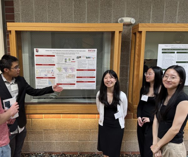
After presenting their project at the National Conference on Undergraduate Research (NCUR) in Pittsburgh, Lau and Zhao received additional funding from Seattle U’s Lemieux Library to continue their research project into the following summer. The project expanded into a larger team, including some local high school students.
Twin sisters Alice and Angela Han, both third-year CS majors, joined the project this past summer to help expand and optimize the research.
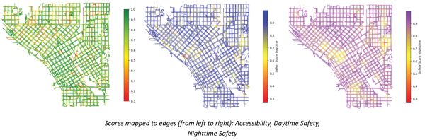
“We added stuff like crime data, accessibility data and light data—because you know, it’s safer to walk when there’s lights around. Then we incorporated all of that into the score so that we had more of a holistic score…the main goal was to test different functions to see what was the best way to optimize walkability versus slope versus distance for routes,” Alice Han said.
For Tony Nguyen, a third-year CS major, working on the walkability project gave him a chance to focus on his interest in AI applications. Nguyen explained that AI offers advantages to the project and, overall, demonstrates how AI can be applied as a useful tool.
“[It] especially helps fill in gaps that people can’t do on their own, because previous methods of evaluating walkability involved people having to manually look, manually go through the streets or use other methods that were not as efficient or easily accessible as using AI to look through these street images and give them a score,” Nguyen said.
Nguyen’s main contribution to the research project was feeding Google Street View images to AI and then prompting it to score those images based on three categories: accessibility, safety and visual appeal. To create a more holistic concluding score, Nguyen ensured the AI model had as many factors as possible to consider when creating the walkability scores.
Based on the model’s results, the team of students reaffirmed previous findings, zeroing in on some of the lowest scores within Seattle’s CID. They then reached out to community organizations in those neighborhoods: Friends of Little Saigon, Seattle Downtown Community Council and Historic South Downtown to share the walkability scores they had produced.
“We gave them the scoring data for the area that they’re concerned with so they could use those scores to determine which areas need improvement in which categories,” Angela Han said.
At the end of their 10-week program, the students submitted their research findings to NCUR and are now awaiting publication. Alice Han shared that while Bae wanted the students to focus more on developing the research behind the idea, they might consider turning their findings into a usable website or app in the future.